Brevard County, FL Zoning Map: How to Read It for Land
Where the official map is, what the zoning codes mean, and how to spot a CDD on the tax bill.
The official Brevard County zoning map is the county's Zoning Map link on the Planning & Zoning page. The county says it shows a property's official future land use and zoning classification in unincorporated Brevard. It covers reading the map for a vacant lot, the zoning codes, and the district charges on the tax bill.
Quick check before you buy a lot in Brevard
- 1.Find out whether the lot is in unincorporated Brevard or inside a city. The county map covers unincorporated land only, so a lot inside a city answers to that city's zoning.
- 2.Open the county zoning map, find the parcel and write down the zoning code and the future land use.
- 3.Look up that code in the county's zoning code, read the minimum lot size and permitted uses, and check the lot meets the minimum.
- 4.Open the property appraiser's parcel record and pull the legal description, acreage and any listed districts.
- 5.Read the non-ad valorem lines on the tax bill. A line with "CDD" in the name is a special district charge.
- 6.Check the flood zone and wetlands (see the section below), and ask the health department about septic if there is no sewer.
- 7.Call Planning & Zoning with the parcel number and ask what can be built. Get the answer in writing if the deal depends on it.
Find the zoning, step by step
You need a parcel number or an address and a browser. The labels below come from the county pages as we found them on 2026-10-29.
Step 1. Open the county's Planning & Zoning page. Find it at brevardfl.gov/PlanningAndDevelopment/PlanningAndZoning. The page has a "Zoning Map" link, and the county text beside it says to use it to determine a property's official future land use and zoning classification within unincorporated Brevard County. The county's GIS Open Data Hub has the underlying layers.
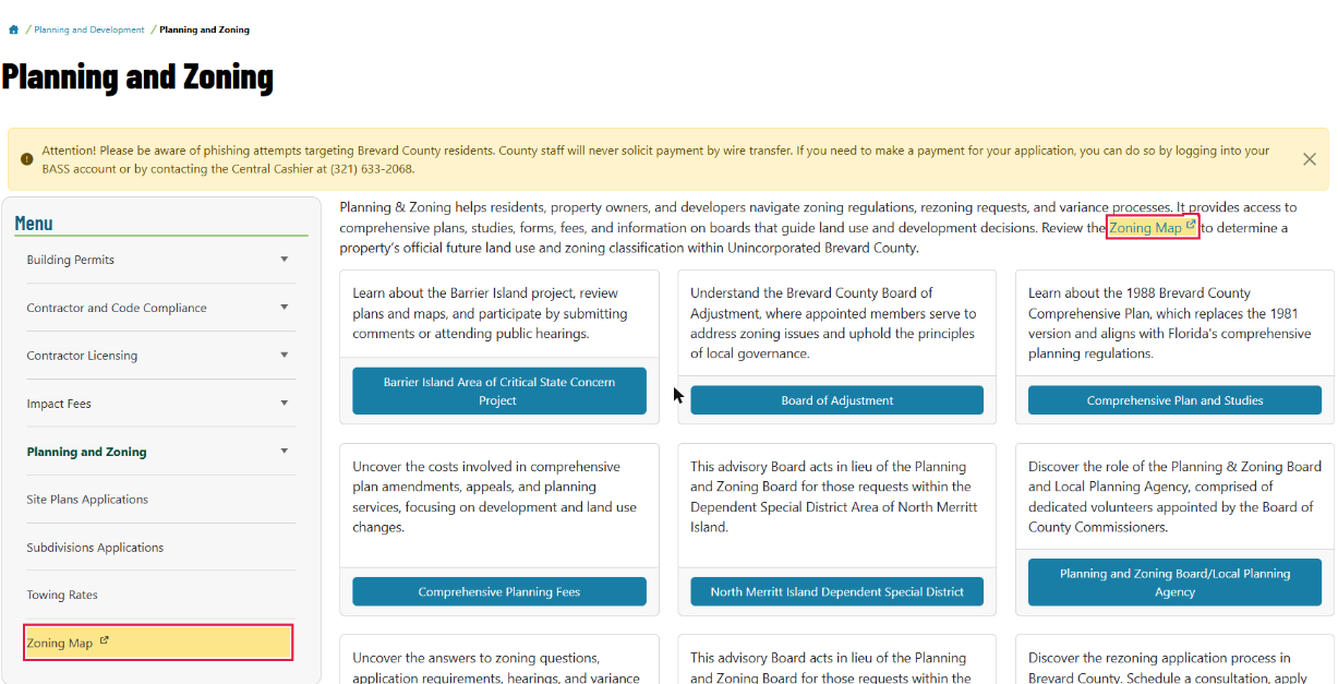
Brevard County Planning and Development, Planning and Zoning page (October 2026).
Step 2. Search the parcel on the map. The map opens with a Disclaimer and Terms of Use box; read it and tick the box to continue. Then type the address, or pan to the lot if it has none. Click the parcel, read the zoning code (for example GU, AU or RR-1) and the future land use designation. Screenshot it with the date.
Step 3. Confirm the parcel in the property appraiser's records. Brevard's property appraiser (BCPAO) publishes parcel records at bcpao.us. Match the parcel ID, acreage and legal description to what the seller gave you. A map click can land on a neighbor's parcel.
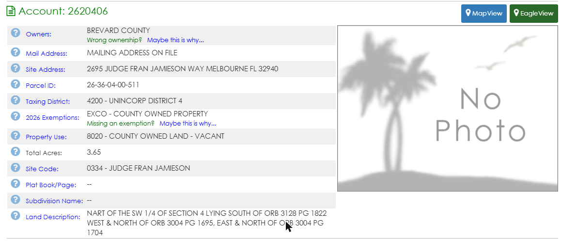
Brevard County Property Appraiser (bcpao.us), parcel record (October 2026). Mailing address hidden.
Step 4. Read the zoning code for that district. Brevard's zoning rules sit in Chapter 62, Article VI of the county's Code of Ordinances on Municode. Division 3 lists the zoning classifications. Division 4 has one section per district, grouped into subdivisions (RR-1, for example, sits under Subdivision II). Look for "Minimum lot size", the permitted uses and the setbacks.
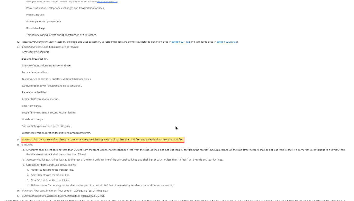
Brevard County Code of Ordinances on Municode, Sec. 62-1336 Rural residential, RR-1 (October 2026).
Step 5. If the boundary looks close, ask. The code has rules for reading a boundary that runs along a street, a lot line or a shoreline (Sec. 62-1252). It also names the county's zoning official as custodian of the official maps (Sec. 62-1251). Ask the official which side of the line your lot sits on.
For general background on zoning designations, see Zoning Designations Explained.
Brevard zoning codes in plain English
The county's code establishes dozens of classifications. These are the ones a land buyer meets first, in the unimproved, agricultural and residential group (Sec. 62-1255). Lot minimums are quoted from each district's section in Division 4. Read the full section, since conditional uses and setbacks vary.
| Code | Name in the code | Plain meaning | Minimum lot size per the code |
|---|---|---|---|
| GU | General use | A catch-all, often seen on unimproved land | Read Sec. 62-1331 before you assume anything |
| PA | Productive agricultural | Land the county wants protected for farming | Read Sec. 62-1332 |
| AGR | Agricultural | Farming zone | Read Sec. 62-1333 |
| AU | Agricultural residential | Farming plus spacious single-family homes | 2.5 acres, 150 ft wide and 150 ft deep (Sec. 62-1334) |
| REU | Rural estate use | Low-density homes, a transition from farm to suburb | 2.5 acres, 200 ft wide and 200 ft deep (Sec. 62-1335) |
| RR-1 | Rural residential | Single-family homes on large lots | 1 acre, 125 ft wide and 125 ft deep (Sec. 62-1336) |
| SEU | Suburban estate residential | Single-family, estate-style lots | Read Sec. 62-1337 |
| SR | Suburban residential | Single-family, suburban lots | Half an acre, 100 ft wide and 150 ft deep (Sec. 62-1338) |
| EU, EU-1, EU-2 | Estate use residential | Larger-lot single-family | Read Sec. 62-1339 |
| RU-1-13, RU-1-11, RU-1-9, RU-1-7 | Single-family residential | Town-sized single-family lots | Read Secs. 62-1340 to 62-1342 |
Unincorporated Brevard also uses codes like PUD (planned unit development) with site-specific rules, so a PUD lot needs the PUD's own documents. A code also tells you only what the district allows in general. You still have to find out whether this lot is large enough, has road access, or can get a septic permit. See Legal Access and Road Frontage for the access side.
We list only the single-family and agricultural intent in the code's own wording. Uses differ by district and change by ordinance, so read the permitted-use list for your code.
Special districts: Viera, Heritage Isle and other CDDs
A community development district (CDD) is a special district that bills owners for the roads, drainage and amenities in a development. On a Brevard lot, the charge shows up on the property tax bill as a non-ad valorem assessment. Your buyer pays it every year, whatever the lot price was.
On the Brevard tax bills we've pulled (2026 bills, checked by hand on the tax collector's site on 2026-10-27), annual CDD charges run from about $135 to about $3,003. We name no owners or parcels here.
- Viera Stewardship CDD: about $135 a year.
- Viera East CDD: about $453 a year.
- Heritage Isle CDD: about $1,478 a year.
- The high end, about $3,003, was a different CDD on the barrier-island side.
Charges vary by lot type and by year.
How to spot a CDD on the bill. Open the parcel's bill on the Brevard County tax collector's site (the page has the collector's contact information and links to property tax payment). Scroll to the non-ad valorem assessments. Each line names a district and an amount, and the line with "CDD" in the name is the one you want. The same section on our bills also showed county fire assessments, solid waste, stormwater and a water district. One city bill had no solid waste collection line, and a vacant lot's bill showed most service lines absent, so it may look lighter than a built lot's.
A missing line proves little. A control lot with no CDD showed none. But some CDDs bill owners directly instead of through the tax bill, so a clean tax bill can still hide a district. Ask the seller, and check the plat and title work.
For what CDD fees are, who sets them and whether they ever end, see What Is a CDD Fee?. For deed restrictions and HOAs, see HOA, Deed Restrictions and CDDs.
Flood, wetlands and septic in Brevard
The zoning map shows none of these. Check each one separately.
- Flood. Look up the parcel on FEMA's Flood Map Service Center (msc.fema.gov) and note the zone. How to Read a FEMA Flood Map for Vacant Land walks through it, and FEMA Flood Zone Classifications Explained covers the letters. Call the county for any building rules tied to the zone.
- Wetlands. The U.S. Fish and Wildlife Service's National Wetlands Inventory mapper gives a first look, and it is not a legal determination. See Wetlands Verification for the steps.
- Septic. A lot without a sewer connection needs a septic permit. The Florida Department of Health in Brevard County runs an Environmental Public Health program with an Onsite Sewage Disposal section, which lists construction permits. Ask what a lot your size needs, since a lot can meet the zoning minimum and still fail on septic.
Who to call in Brevard
We re-checked each contact on the county's own pages and left off any number that did not load or match.
| Office | Call about | Contact | Status |
|---|---|---|---|
| Planning & Zoning | Zoning code, boundary questions, rezoning | (321) 633-2069 | Confirmed on the page 2026-10-29 |
| Tax Collector | Tax bill lines, CDD charges, delinquent taxes | (321) 264-6969 | Confirmed on the page 2026-10-29 |
| DOH-Brevard Environmental Public Health | Septic permits | See the page for the current line | Number not re-confirmed |
| Property Appraiser (BCPAO) | Parcel records, acreage | See the site for the current line | Number not re-confirmed |
Use a title company for CDD and lien searches, and a surveyor if the lot lines or a zoning boundary are in doubt.
Screening many Brevard lots by hand means a map, a parcel record and a tax bill for each one. Confirm the details with the county.